
Paharpur
Paharpur is a town of Dera Ismail Khan District in Khyber Pakhtunkhwa, Pakistan. The town is the headquarters of Paharpur Tehsil, an administrative subdivision of the district, and is a Union Council.[1] It is located at 32�6'8N 70�58'12E and has an altitude of 173 metres (570 feet).[2] Darul uloom chishtia rizvia led by a famous scholar Zahir Shah Qadri jamia mehria islamia led by Qari Hasan Ali Mueeni gulzareMadina led by G Yasin chishti are famous for religious education. Mulla Nazar, Hasan shah, matti Sultan Pir Ashab, Kamboh shrif are holy shrines. Dera Ismail Khan (Pashto: , Urdu: ) is a city in Khyber-Pakhtunkhwa Province, Pakistan. It is situated on the west bank of the Indus River, 200 miles (320 km) west of Lahore and 120 miles (190 km) northwest of Multan.[1] The city is the capital of the district and tehsil of the same name. In Pakistan, its name is often abbreviated to D. I. Khan.[2] Dera Ismail Khan was founded toward the end of the fifteenth century by Ismail Khan, a son of the Arab adventurer Malik Sohrab, who named the town after himself. Dera means "settlement" or "abode". The original town was swept away by a flood in 1823, and the existing buildings are all of relatively modern construction.[1] The present town stands four miles (6 km) back from the permanent channel of the river. However, later research does not support this theory. Firstly, Malik Sohrab was not an Arab adventurer but a Hote Baluch who was appointed Soobadar of this area by the Langha rulers of Multan. Similarly the city could not have been founded towards the end of fifteenth century; because when Babar came here in 1506 he passed through this plane which is now called Dama'an and referred to it as Dasht and went up to Tank but did not mention any city around here in his Tuzk (Memoirs, originally published in Turkish). Later we are told that when in 1540 Sher Shah came to Khushab, Ismail Khan of Dera Ismail Khan went to Khushab to meet him there. So the city must have been founded in the first quarter of the sixteenth century.[3] After the flood destruction of 1823, the present city was founded by Nawab Sher Muhammad Khan Sadozai in 1825, but he preferred to retain the old name for it.
Kulachi
Kulachi is a town and headquarter of Kulachi Tehsil of Dera Ismail Khan District in Khyber-Pakhtunkhwa province of Pakistan. It is located 45 km from Dera Ismail Khan in the Damaan valley, and lies on the banks of the Gomal River (local name “Luni” or “Khuarha”), a tributary of the Indus.
The city is bordered by a wall, and has four bazaars in the shape of a cross. The centre of the bazaars is known as Chowgalla (Square).Pashto and Saraiki are spoken in Kulachi,
The city was developed by Hussain Khan, who had fallen out with his tribe living in the area now included in the District of Dera Ghazi Khan. He with some of his supporters came here and the area was given to them by the Gandapur Tribe. They went back after a patch up and the city since then is inhabited by Gandapurs. The story that Gandapurs expelled them after a fight does not have any evidence to support it. The fighting between the Hote Sardars of Dera ismail Khan and Gandapur tribes took place somewhere towards the end of the eighteenth century and by then Hussain Khan had already gone back to his tribe and his area.
The Imperial Gazetteer India, Volume 16, Page 13 describes Kulachi as below:
Kulachi Town. Head-quarters of the tahsil of the same name in Dera Ismail Khan District of Khyber-Pakhtunkhwa, situated in 31’ 56” N. and 70’ 28” E., on the north bank of the Luni torrent; 27 miles west of Dera Ismail Khan town. Population (1901), 9,12,5. It is rather an aggregation of sixteen separate hamlets, standing near the union of their lands, than a regular town. A municipality was created in. 1867, and its income and expenditure during the ten years, ending 1902-3 averaged Rs. 6,900. In .1903-4 the income was Rs. 7,200, chiefly derived from octroi; and the expenditure was Rs. 7,100. The place formerly carried on a brisk trade with the Wazirs of the hills, which declined before annexation, but has since somewhat revived, Kulachi contains a Government dispensary; and its principal educational institution is an Anglo-vernacular middle school maintained by the District board. ”
Herbert Edwards while ending his chapter on Kulachi writes “Let me remind my readers that they need not go to Kulachi, unless they are in search of two things; very brave soldiers and very sweet melons”
Economy
Kulachi is situated at the foot of the Sulaiman Mountains and therefore is irrigated by flood water from Sulaiman Mountains. The system of irrigation is called Rod Kohi, a system of mountain channels or hill-torrents inundating the whole valley of Damaan (“Rod” means “channel” and “Koh” means “mountain” in Persian). The Rod Kohi system based on “Kulyat Riwajat” (Fromulae and Traditions) governed the irrigation system eversince the Pathan tribes had moved into Damaan. The British officers reduced all these to writing during their Land Settlemts in the later part of nineteenth century. The Bolton Irrigation Notes of 1908 are still considered as the Bible of Rod Kohi Irrigation. The quality of soil being very good in good years when the Rod Kohi dams work and there are sufficient rains and floods; the area had been the most productive area in food grains in the district. (Now the area of two districts D,I,Khan and Tank. However the system of Rod Kohi irrigation is now in shambles due official neglect, political interferences and non allotment of sufficient funds by the Provincial Government. However, the work on the Gomal Zam Dam Project was resumed in 2001 after almost forty years and the Dam being constructed by a Chinese Firm, will change the economic scenario of the area and its principal city.
Handy Crafts of Kulachi
Kulachi is famous for various artifacts and handicrafts.
Kulachiwal Chaakku (Knife). Small knives with attractive design are manufactured on a small scale by artisans in Kulachi. This beautiful art is on the verge of extinction due to lack of Government support.
Handicrafts. A variety of beautiful handicrafts, similar in style to Multani handicraft, are made in the area.
Ornamental Shoes. Commonly known as “Tillay dar chaplai”, the ornamental shoes made by the local cobblers are very popular in the area. They are suitable for long walks in the fields of Damaan.
The City of Saints
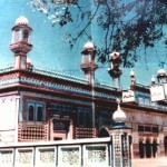
Kulachi is famous for the presence of shrines of various Sufi saints. The most notable among them are: tomb of Mian Baraan Dadaa (in Pashto, Dadaa means grandfather or respectable elderly gentleman), tomb of Maddey Khan, tomb of Khair Shah, tomb of Bukhari Dadaa, tomb of Bahadur (Baz daada), tomb of Hazrat Syed Karam Shah (Lakhan Khatman Wala) (recited Quran more than 100,000 times), tomb of Razau Dadaa and tomb of Noor Muhammad (Noori Darbaar). Most of these tombs have surrounded the walled city of Kulachi.
The city is bordered by a wall, and has four bazaars in the shape of a cross. The centre of the bazaars is known as Chowgalla (Square).Pashto and Saraiki are spoken in Kulachi,
The city was developed by Hussain Khan, who had fallen out with his tribe living in the area now included in the District of Dera Ghazi Khan. He with some of his supporters came here and the area was given to them by the Gandapur Tribe. They went back after a patch up and the city since then is inhabited by Gandapurs. The story that Gandapurs expelled them after a fight does not have any evidence to support it. The fighting between the Hote Sardars of Dera ismail Khan and Gandapur tribes took place somewhere towards the end of the eighteenth century and by then Hussain Khan had already gone back to his tribe and his area.
The Imperial Gazetteer India, Volume 16, Page 13 describes Kulachi as below:
Kulachi Town. Head-quarters of the tahsil of the same name in Dera Ismail Khan District of Khyber-Pakhtunkhwa, situated in 31’ 56” N. and 70’ 28” E., on the north bank of the Luni torrent; 27 miles west of Dera Ismail Khan town. Population (1901), 9,12,5. It is rather an aggregation of sixteen separate hamlets, standing near the union of their lands, than a regular town. A municipality was created in. 1867, and its income and expenditure during the ten years, ending 1902-3 averaged Rs. 6,900. In .1903-4 the income was Rs. 7,200, chiefly derived from octroi; and the expenditure was Rs. 7,100. The place formerly carried on a brisk trade with the Wazirs of the hills, which declined before annexation, but has since somewhat revived, Kulachi contains a Government dispensary; and its principal educational institution is an Anglo-vernacular middle school maintained by the District board. ”
Herbert Edwards while ending his chapter on Kulachi writes “Let me remind my readers that they need not go to Kulachi, unless they are in search of two things; very brave soldiers and very sweet melons”
Economy
Kulachi is situated at the foot of the Sulaiman Mountains and therefore is irrigated by flood water from Sulaiman Mountains. The system of irrigation is called Rod Kohi, a system of mountain channels or hill-torrents inundating the whole valley of Damaan (“Rod” means “channel” and “Koh” means “mountain” in Persian). The Rod Kohi system based on “Kulyat Riwajat” (Fromulae and Traditions) governed the irrigation system eversince the Pathan tribes had moved into Damaan. The British officers reduced all these to writing during their Land Settlemts in the later part of nineteenth century. The Bolton Irrigation Notes of 1908 are still considered as the Bible of Rod Kohi Irrigation. The quality of soil being very good in good years when the Rod Kohi dams work and there are sufficient rains and floods; the area had been the most productive area in food grains in the district. (Now the area of two districts D,I,Khan and Tank. However the system of Rod Kohi irrigation is now in shambles due official neglect, political interferences and non allotment of sufficient funds by the Provincial Government. However, the work on the Gomal Zam Dam Project was resumed in 2001 after almost forty years and the Dam being constructed by a Chinese Firm, will change the economic scenario of the area and its principal city.
Handy Crafts of Kulachi
Kulachi is famous for various artifacts and handicrafts.
Kulachiwal Chaakku (Knife). Small knives with attractive design are manufactured on a small scale by artisans in Kulachi. This beautiful art is on the verge of extinction due to lack of Government support.
Handicrafts. A variety of beautiful handicrafts, similar in style to Multani handicraft, are made in the area.
Ornamental Shoes. Commonly known as “Tillay dar chaplai”, the ornamental shoes made by the local cobblers are very popular in the area. They are suitable for long walks in the fields of Damaan.
The City of Saints
Kulachi is famous for the presence of shrines of various Sufi saints. The most notable among them are: tomb of Mian Baraan Dadaa (in Pashto, Dadaa means grandfather or respectable elderly gentleman), tomb of Maddey Khan, tomb of Khair Shah, tomb of Bukhari Dadaa, tomb of Bahadur (Baz daada), tomb of Hazrat Syed Karam Shah (Lakhan Khatman Wala) (recited Quran more than 100,000 times), tomb of Razau Dadaa and tomb of Noor Muhammad (Noori Darbaar). Most of these tombs have surrounded the walled city of Kulachi.
Sheikh Badin Hills
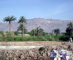
Going through the Indus highway to Dera Ismail Khan to Peshawer, The Sheikh Badin Hill situated on the East of Pezu at a height of 1400m above sea level, 2 hour drive from Dera Ismail Khan and an hour rough drive from Pezu.
One end of its base is marked by the presence of the repulsive looking Lucky Cement Factory, reputed to be Asia’s largest cement producing plant. The other end overlooks the beautiful town of Paniala, famed for its gardens, saints, and “exploding mangoes”. Amongst the inhabitants of Paniala, Marwats constitute the bulk of the population. There are also a small number of Seraikis, and members of a tribe unique to this area only known as the Brhach’s, though most of them are now absorbed into the Marwats.
It is believed that saint named Gulani Faqir or Haji Baba came to this desolate place in the midst of the desert and found a people much more devout than those in the nearby areas. As a gift to these people, the saint struck the ground with his staff and a steady gush of water started to ooze out. He then mounted his horse and rode around the town, with the water flowing wherever he went. Today, the oasis town is encircled by a stream with a steady flow of underground water, which the locals attribute to the legend. Finally, the saint prayed that the people themselves only consume the fruit from the gardens of this oasis. The Paniala mangoes are thus famed for bursting open if taken far from the oasis itself. Other saints who are buried here are the Ashab-e Rasool (Companions of the Prophet PBUH), Ahmad Malarha, Lewani Shedan, Ali Sheikh & Jiway Lal Malang.
It is very difficult to find the fact that this dull looking hill overlooking Paniala would house a massive cantonment of British era, ignored over the years by the local governments, and populated by fugitives until recently. Outwardly, the hill presents a dull look, but the appearance of the station at the top of the hill is hideous. The whole hill is mostly composed of sand-stone, limestone and clay, hence it is a rich resource for meeting construction requirements in the district. There is also the presence of wild olives, acacia and dwarf palm trees.
The first settlement in Sheikh Badin was by Sheikh Baha’udin (not to be confused with Baha’udin Zikria, although he is also reputed to have spent 13 years here before moving on to Multan). He moved in from Sopur in Kashmir some four hundred years ago. His offspring still lives and occupies the top and are locally known as the Pir’s of Sheikh Badin.
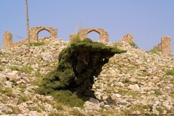
The second major settlement was made by the British in 1860, which made it their summer head-quarters. All essential offices, Police, District Magistrate, Treasury, Commissioners, and a small hospice would operate from here, away from the sweltering heat of the Dera & Bannu plains. Being a cantonment, it was strictly off-limits to the locals who would have to leave by two and retreat to the nearest caravan-serai halfway down the hill. Troops would patrol a path surrounding the cantonment for security purpose. The only other site outside the limits of the cantonment was the graveyard, now in a desolate condition. There were marks on the graves but much of the grave-stones have been stolen over the years.
About the hill station, one of the first settlement officers, Major Urmston writes in 1864 that, “There are no two opinions on the healthiness of the sanatorium. It has been proved beyond doubt to be a most valuable place of resort for officers and families on the frontier during the hottest months of the year; and, after the experience of two seasons, I can safely affirm that, though its outward appearance is less attractive than other hill stations, its beneficial effects upon the constitution, especially of ladies & children, are very great. The cool breeze which sets in towards sunset is very refreshing, and dense fogs and clouds are rare.”
Ownership rights for all the land was with the British. They however made two exceptions. The first being grant of 14 kanals to the Pir’s family managing the shrine, and the second being grant of 1.5 kanals to an unknown influential Hindu from Bannu. The British kept on utilizing this hill station until 1914, when due to military engagements in nearby Waziristan, they moved camp to Wana.
The cantonment premises at the top houses 15 bungalows, a police station, jail, squash court, rest house, post office, a small bazar with just two shops, the tomb of Sheikh Baha’udin, and housing compounds of the Pir families. Stone & wood is used in construction and most of the structures present an unfinished look. This settlement at the top is made in a central depression which is likened to an extinct crater, though the hill is by no means volcanic in character.
Water is a major problem of this area. The British constructed many pools for storage of water in this depression. These would be filled during the rainy season and its water utilized with the help of Karez system for irrigation purpose and provision of water to the lush green gardens and lawns. Although the gardens have vanished, the karez system is still present, though not in use anymore. Drinking water was and is arranged by hiring water-carriers for a nominal amount that in turn bring it up on donkeys from springs at the foot of the hill near Paniala.
A cold breeze always blows across the top day or night. The wildlife department has also declared the area to be a wild-life park, although no animals were in sight, and a large tract of land was burnt due to forest fires caused due to thunder earlier this year. The hill was home to a wide range of animals, most notable of which were leopards, wolves & urials.
Strangely, during the last decade, the government had handed out contracts by auction for the demolition of a number of these historical structures to make way for “Dera Township”, which would include residential & business areas, a campus of Gomal University, other district offices, and parks. Many political & influential figures managed to secure these contracts and occupied the premises illegally for personal purposes. Some even started selling land which they did not own or which never existed.
Let’s hope the establishment sticks to their promise and restore the past glory which the hill station enjoyed.
One end of its base is marked by the presence of the repulsive looking Lucky Cement Factory, reputed to be Asia’s largest cement producing plant. The other end overlooks the beautiful town of Paniala, famed for its gardens, saints, and “exploding mangoes”. Amongst the inhabitants of Paniala, Marwats constitute the bulk of the population. There are also a small number of Seraikis, and members of a tribe unique to this area only known as the Brhach’s, though most of them are now absorbed into the Marwats.
It is believed that saint named Gulani Faqir or Haji Baba came to this desolate place in the midst of the desert and found a people much more devout than those in the nearby areas. As a gift to these people, the saint struck the ground with his staff and a steady gush of water started to ooze out. He then mounted his horse and rode around the town, with the water flowing wherever he went. Today, the oasis town is encircled by a stream with a steady flow of underground water, which the locals attribute to the legend. Finally, the saint prayed that the people themselves only consume the fruit from the gardens of this oasis. The Paniala mangoes are thus famed for bursting open if taken far from the oasis itself. Other saints who are buried here are the Ashab-e Rasool (Companions of the Prophet PBUH), Ahmad Malarha, Lewani Shedan, Ali Sheikh & Jiway Lal Malang.
It is very difficult to find the fact that this dull looking hill overlooking Paniala would house a massive cantonment of British era, ignored over the years by the local governments, and populated by fugitives until recently. Outwardly, the hill presents a dull look, but the appearance of the station at the top of the hill is hideous. The whole hill is mostly composed of sand-stone, limestone and clay, hence it is a rich resource for meeting construction requirements in the district. There is also the presence of wild olives, acacia and dwarf palm trees.
The first settlement in Sheikh Badin was by Sheikh Baha’udin (not to be confused with Baha’udin Zikria, although he is also reputed to have spent 13 years here before moving on to Multan). He moved in from Sopur in Kashmir some four hundred years ago. His offspring still lives and occupies the top and are locally known as the Pir’s of Sheikh Badin.
The second major settlement was made by the British in 1860, which made it their summer head-quarters. All essential offices, Police, District Magistrate, Treasury, Commissioners, and a small hospice would operate from here, away from the sweltering heat of the Dera & Bannu plains. Being a cantonment, it was strictly off-limits to the locals who would have to leave by two and retreat to the nearest caravan-serai halfway down the hill. Troops would patrol a path surrounding the cantonment for security purpose. The only other site outside the limits of the cantonment was the graveyard, now in a desolate condition. There were marks on the graves but much of the grave-stones have been stolen over the years.
About the hill station, one of the first settlement officers, Major Urmston writes in 1864 that, “There are no two opinions on the healthiness of the sanatorium. It has been proved beyond doubt to be a most valuable place of resort for officers and families on the frontier during the hottest months of the year; and, after the experience of two seasons, I can safely affirm that, though its outward appearance is less attractive than other hill stations, its beneficial effects upon the constitution, especially of ladies & children, are very great. The cool breeze which sets in towards sunset is very refreshing, and dense fogs and clouds are rare.”
Ownership rights for all the land was with the British. They however made two exceptions. The first being grant of 14 kanals to the Pir’s family managing the shrine, and the second being grant of 1.5 kanals to an unknown influential Hindu from Bannu. The British kept on utilizing this hill station until 1914, when due to military engagements in nearby Waziristan, they moved camp to Wana.
The cantonment premises at the top houses 15 bungalows, a police station, jail, squash court, rest house, post office, a small bazar with just two shops, the tomb of Sheikh Baha’udin, and housing compounds of the Pir families. Stone & wood is used in construction and most of the structures present an unfinished look. This settlement at the top is made in a central depression which is likened to an extinct crater, though the hill is by no means volcanic in character.
Water is a major problem of this area. The British constructed many pools for storage of water in this depression. These would be filled during the rainy season and its water utilized with the help of Karez system for irrigation purpose and provision of water to the lush green gardens and lawns. Although the gardens have vanished, the karez system is still present, though not in use anymore. Drinking water was and is arranged by hiring water-carriers for a nominal amount that in turn bring it up on donkeys from springs at the foot of the hill near Paniala.
A cold breeze always blows across the top day or night. The wildlife department has also declared the area to be a wild-life park, although no animals were in sight, and a large tract of land was burnt due to forest fires caused due to thunder earlier this year. The hill was home to a wide range of animals, most notable of which were leopards, wolves & urials.
Strangely, during the last decade, the government had handed out contracts by auction for the demolition of a number of these historical structures to make way for “Dera Township”, which would include residential & business areas, a campus of Gomal University, other district offices, and parks. Many political & influential figures managed to secure these contracts and occupied the premises illegally for personal purposes. Some even started selling land which they did not own or which never existed.
Let’s hope the establishment sticks to their promise and restore the past glory which the hill station enjoyed.
Soloman’s Peak (Koh-i Sulaiman)
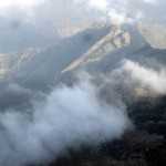
The legend is of the Sulaiman mountain range, east of Dera Ismail Khan, overlooking the plain of the Indus River.
The highest peak is called Takht-i Sulaiman, Solomon’s Throne; Ibn Battuta (Historian) called it Solomon’s Peak (Koh-i Sulaiman). Ibn Battuta retells the story that the Jewish prophet Solomon climbed this mountain and looked out over the land of South Asia, which was then covered with darkness – but he went back without downward into this new frontier, and left only the mountain which is named after him.
People in Damaan also believe that Prophet Sulaiman, by exercising his miraculous power, had confined those mischievous Jinns inside it who had refused to obey his command. The evil-spirited Jinns are supposed to remain imprisoned almost all the year, and in Safar, the second month of the Islamic calendar, they are allowed to go free for a while. During this month, after darkness falls over the region, mothers restrict their children within their homes as a precaution against the evil effects of these Jinns.
Takht-i-Sulaiman rises to a height of 3382 meters above sea level. A trip to the mountain is undertaken mostly in summer, and in winter heavy snowfall makes it difficult to approach it from late November until March. Animal sacrifice is an essential feature of a visit to Sulaiman. The locals believe that infertile women can be blessed with fertility when they visit Takht-i-Sulaiman.
Religious connotations apart, Takht-i-Sulaiman is an area of outstanding natural beauty, boasting spectacular mountains, which offer endless opportunities of trekking and climbing. It can be reached either through Balochistan or Khyber Pakhtoon Khawa. It is advised, for convenience’s sake, to start the journey from D.I. Khan. Draban Kalan, a town 40 miles off to the west, offers a convenient approach to it. Public transport heading up the Ragha Sar, the base of Sulaiman is available here.
Takht-i-Sulaiman is a region of unimaginable beauty, but local loggers pose a serious environmental threat to its very existence. It is time that the concerned authorities take some serious actions to preserve its ecosystem. The government has so far been totally apathetic to this tragedy. It has imposed a ban on the export of the timber from Sulaiman Mountains, but there are more than one ways of smuggling it. Western slops of the range provide an easy access to loggers to Zhob, Balochistan. The government must also pay heed to the genuine problems of Sherani tribal area, and should take concrete measures to eradicate poverty, illiteracy and backwardness from the area.
Toyota Show room D.I.Khan
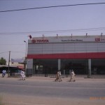
Toyota is a famous multinational company of four wheel vehicles in Pakistan. Its show rooms are situated in each big city of Pakistan.
It was also launched in D.I.Khan in December 1992 to facilitate the peoples of this district. To construct this building, its contract was given to the local contractor. The total expenditure incurred on this project was round about 2 crore. The ownership of this show room was also taken by the local persons. You can make booking and then purchase each new model of Toyota from this show room. Due to its oldness and amazing look, it is considered as a famous place in D.I.Khan.
It was also launched in D.I.Khan in December 1992 to facilitate the peoples of this district. To construct this building, its contract was given to the local contractor. The total expenditure incurred on this project was round about 2 crore. The ownership of this show room was also taken by the local persons. You can make booking and then purchase each new model of Toyota from this show room. Due to its oldness and amazing look, it is considered as a famous place in D.I.Khan.
Ashiana Shopping Center D.I.Khan
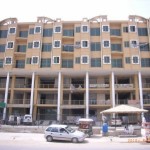
It is the four floor commercial building. It also have ground floor. Its 5th floor is near to finish, which will be used for a marriage hall and the 6th floor will also be constructed according to owner’s plan for restaurant.The construction of this center was started in August 2005 and completed in 2009. The total expenditure incurred on this project was round about 20 crore. Its contract was taken by the “Baig construction company”. It is located on the North- West Circular road.
Its owner’s name is Haji Ramzan Bhitanni (late). This center has also other branches in big cities of Pakistan. After the late Haji Ramzan, his two sons, Haji Nisar Ahmad and Haji Mehmood are supervising these projects. Due to its amazing outlook, now it is considered as a famous place in Dera Ismail Khan.
Its owner’s name is Haji Ramzan Bhitanni (late). This center has also other branches in big cities of Pakistan. After the late Haji Ramzan, his two sons, Haji Nisar Ahmad and Haji Mehmood are supervising these projects. Due to its amazing outlook, now it is considered as a famous place in Dera Ismail Khan.
STATE LIFE BUILDING D I Khan
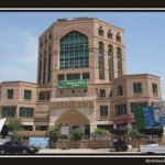
A well known company of Karachi “Naseem and CO.” took a contract to construct the “State Life” Building in Dera Ismail Khan.They started its construction in 1993. This project took 5 years to complete. So this was launched in 1998. The total expenditure incurred on this project was 7 crore+. Its location is on the east-circular road of the city. The main aim to built it was to develop the D.I.Khan city. Now this building is being used by the main companies of Pakistan. This is the beautiful and highest building, so its location is considered as a famous place in D.I.Khan.
DAEWOO D.I.KHAN
Daewoo Pakistan bus service is a famous national bus service. It is a multinational project of a Korean company” Daewoo Pakistan express”.
This service was launched in Dera Ismail Khan on 1st Sep 2005. The total expenditure incurred on D.I.KHAN Daewoo Bus Terminal was 2.5 Crore. Its location is on Bannu road D.I.Khan. Due to its amazing outlook, this is known as one of the beautiful bus terminal in all over the Pakistan Daewoo bus terminal and also due its outlook, a person passing by always praises its beauty, so now it is considered as a famous place in D.I.KHAN.
The average price of one Daewoo Bus is about 1.2 Crore. the internal environment offers lots of facilities, which make it like an aero plane. Comfortable seats, excellent environment, relax journey and the presence of land hostess can make you feel that you are in an aero plane. The internal beauty of waiting lounge of the bus terminal is also like an airport. A big screen is fitted for entertainment and the name of passenger is also called on microphone.
Chogallah
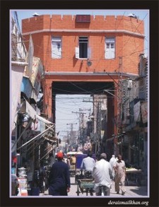
In 1940, the British government had built a strong defence at location of Chogalia in which police and Malaysia could take the position according to situation. It is also the meeting point of 4 main bazaars, i-e, kalan bazar, Muslim bazaar, commisionery bazaar and bakhri bazaar. Under this defence four big gates had adjusted in all four sides by British government to cut the link of four bazaars during bad situation between Hindu and Muslim. These gates are remains same to same today.Now-a-days these gates are closed on the day of Ashoora, 10th Moharam-ul-Haram, Hazrat Imam Hussain’s Shahadat, after the passing of procession.
